
PROJECTS |
KERKENNAH BANKS “3D”The Kerkennah Banks area lies southwest of the Kerkennah Islands. The area has long been considered highly prospective by explorationists since it culminates at the juncture of the Kerkennah Arch and the Ashtart Rift. Two other significant hydrocarbon fields have already been found in this area.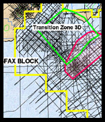 The Chergui gas field is located on the northwestern part of the Kerkennah Islands. Productive from the 10 m thick Eocene Reineche nummulitic limestone, the field was discovered in 1992. A number of appraisal and development wells were drilled between 1993 and 1997. The Chergui field is a faulted structure with four fault segments, two of them have been drilled and it has flowed gas from three wells (Chergui #1A, #3 & Chergui #5). OMV, a former interest owner has reported initial gas in place of >120 BCF for the two fault segments drilled to date.
The Cercina Oil field is also productive from the Eocene Reineche nummulitic limestone where it is better developed than at Chergui. OMV, the operator, has reported that as much as 22 million barrels of oil will be recovered from this small accumulation. From rather sparse 2D seismic coverage APEX had mapped a number of leads within the Kerkennah Banks area. Anadarko Petroleum Corp proposed a 420 sq km. transition zone 3D survey of the area to solidify these leads. The survey was initiated on February 17, 2007 with CGG being the preferred contractor. Despite a number of difficulties imposed by Mother Nature, the survey was completed the first week in July at a cost of $15,498,000 USD. The final processed data is expected by the end of November. |